Archive for the ‘Geological Mapping’ Category

Making Sense of 2-D Data : Part 2 – Folds

Making Sense of 2-D Data : Part 2 – Folds

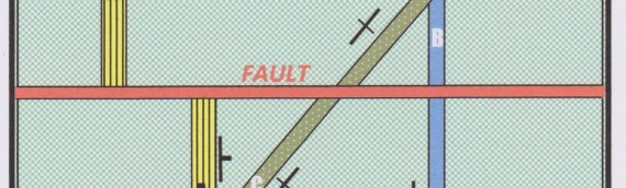
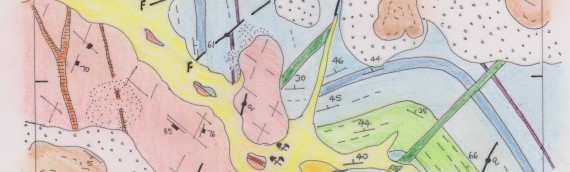
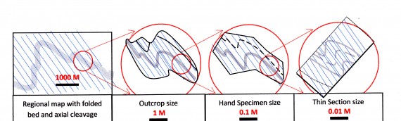
MAKING SENSE OF 2D DATA – PART 2: FOLDS This post is the second of three parts (for parts 1 and 3, see here and here) and describes the different appearances which folds can have depending on the orientation of the surface on which they are exposed. […]

Read more

Making sense of 2-D Data – Part 1: Faults

Making sense of 2-D Data – Part 1: Faults

Visualizing complex objects in three dimensions isn’t easy, although geologists are better at this than most. Two dimensional objects are an order of magnitude easier to comprehend. Where the object under study is complex we can gain an understanding by viewing it on two dimensional slices or […]

Read more

Is there such a thing as a geological fact map?

Is there such a thing as a geological fact map?

  Is there a sense in which a geological map can be described as a representation of fact? Can a map define “ground truth?” A map is a virtual reality representation of the world in two dimensions. A geological map is a human artefact constructed according to […]

Read more

Map scales

Map scales

The most fundamental feature of any map is its scale. The scale of a map is the ratio of a length of a unit line on the map to the length that that line represents in the real world.   The ratio is expressed as a fraction that […]

Read more

Geological Interpretation of Air Photo and Satellite Images

Geological Interpretation of Air Photo and Satellite Images

Air photographs (along with other similar remote sensed products such as satellite and radar imagery) provide both a mapping base on which to record field observations and an integrated view of landscape on which map-scale patterns of lithology and structure can be directly observed or interpreted.  Where […]

Read more

Choosing the right scale – Regional Exploration

Explorers for minerals work with maps. The scale of the map controls the detail of the information that can be shown. With geological, geophysical or geochemical information, State Surveys , typically, present their data at regional scales ranging from 1:250,000 down to 1:50,000 : these aim to […]

Read more

The Camera and the Interrogator

The Camera and the Interrogator

The camera and the interrogator How odd it is that anyone should not see that all observations must be for or against some view if it is to be of any service. Charles Darwin, 1870 Speak to exploration geologists and you will find two views about what a […]

Read more

Vergences and Fractals

Vergences and Fractals

Vergences and fractals Field geologists have long known that the style and relationships of structures seen in a hand specimen, outcrop or drill core can mimic the style and relationships of much larger structures that formed during the same deformation but occur at the scale of a geological […]

Read more

The Movement of Faults

The Movement of Faults

  All metal deposits that have formed later than the rocks that host them (that is, epigenetic deposits) have got there by virtue of fluid transport along faults and their location, shape, size and attitude are largely determined by the strain states that existed within the fault […]

Read more

The invention of the Palaeozoic

The invention of the Palaeozoic

The science of geology was born in the last few decades of the 18th and the first few decades of the 19th  centuries. Its development was one of advancing ideas and knowledge, but  the new knowledge above all was driven by the progressive improvement in geological method, and in […]

Read more