The most fundamental feature of any map is its scale. The scale of a map is the ratio of a length of a unit line on the map to the length that that line represents in the real world. The ratio is expressed as a fraction that divides the unit length (1) on the map by the actual length which that unit represents. The fraction is written 1 : X where “X” is whatever scaling factor you have chosen. If X is a relatively small number (say, 10 or 50) the ratio – 1:10 or 1:50 – is a relatively large fraction. For this reason scale ratios with small “X” numbers are referred to as being large scale. If “X” is a large number (say 100,000or 250,000), then the resulting map scale (1:100,000 or 1:250,000) is referred to as small scale. This nomenclature is somewhat counterintuitive and many people describing maps get this the wrong way round. Just remember: map scales with large numbers are small- scale maps: scales with small numbers are large- scale maps. Large scale maps are able to show much more of the fine detail of the real world than small scale maps(1). Of course the terms “small” and “large” are purely relative and have no absolute meaning except when comparing scales or within a particular context. As a rule of thumb, geological maps with scales from 1 (1:1) to 5000 (1:5000) would generally be referred to as large scale maps, while scales of 50,000 and upwards are generally thought of as small-scale. For scales in the range 5,000-50,000 you definitely need a context before attempting description.
A “natural scale” is where scale ratios, usually in multiples of ten, are used and are expressed purely as a number ratio rather than in terms of a linear measure. Natural scales based on 10 work well in combination with the metric or SR system of measurement, which is also based on 10. Thus at 1:100 scale, 1 centimetre (cm) on the map is 100 cms (1 metre) on the ground, 1.37cms is 1.37 m. At 10,000 scale, a map cm represents 1000 metres or 1 kilometre. Measuring distances on the map is simple and intuitive. A 1:10,000 scale could be referred to as a one centimetre to one kilometre scale, or a one inch to one thousand inch scale, or a one yard to one thousand yard scale but “ten thousand scale” is much the simplest and most direct descriptor.
The Anglo-Saxon world, even today, clings to medieval measuring systems involving feet/inches/miles or pounds/stones. North America in particular being a major hold-out against modernity and scientific usage. Until just a few years ago these countries constructed their geological and topographic maps using the linear measures: inches, feet and miles - and sometimes even more obscure units such as chains or furlongs. In the United Kingdom these are called Imperial Measurements. On such maps the unit line chosen is generally one inch allowing a standard inch ruler to be used to measure distance on the map. A small-scale map might therefore be constructed so that 1 inch = 1 mile, which translates to a scale ratio of 1:63,360. This would always be called an inch-to-the-mile map, never a one-to-sixtythreethousandthreehundredandsixty map (for obvious reasons). A large scale map might use 1 inch = 100 feet (1:1200) . Measuring distances on maps with these scales can be a problem, for example a distance of one and 3 sixteenths inches (1.1875”) on a map is exactly how long in miles or feet? If you have to think about this for more than a few seconds, or reach for a calculator, then I have made my point. Many historical geology maps that an exploration geologist might come across will use this type of scaling. In the USA, Government Surveys are still publishing new geological maps at 1 inch = 1 mile.
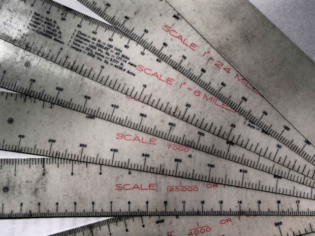
A set of Allen scales offers 24 common natural and imperial scales with graduations in feet and meters. Invaluable when dealing with old exploration and mining maps.
Working with and transferring data from and between maps at different scales is difficult enough when they are multiples of simple natural scales. However the task can become a nightmare when scales based on Imperial linear measures have been used. Today the best solution of course is to convert the maps to digital format so that a computer can rapidly present them at any scale required, but this is not always an option when working with old maps. Scanning old paper copy to digital format can be a major and expensive exercise requiring access to a large, industrial, flat-bed scanner. For this task the use of special scale rulers is indicated. I still have my set of Allen scales (see above) that I acquired more than 30 years ago – 12 flexible plastic rulers marked off with 24 scales that fan out from a common pivot. The graduations cover a large range of common scales allowing distances to be read off in both metric and imperial units. These scales live in my field kit and have proved an invaluable tool over the years when examining old mine or exploration records.

A modern triangular scale ruler offers six common natural scales (typically: 100, 200, 250, 400, 500, 600 and can be used for any 10x multiple of these numbers) and covers most map scales that will be encountered on modern maps.
Another very useful tool when dealing with maps at multiple and non-standard scales is the ten point divider (illustrated below). Once the divider is set to the scale of the map using the bar scale on the map, it can be used to measure any distance on the map, down to one tenth of the scale set.
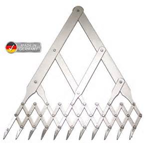 A ten point divider can be set to measure distances on maps of any scale. Alert readers will notice that there are, in fact, 11 points, but the point is (pun intended) that these dividers allow any line to be exactly subdivided into 10 equal portions.
(1) If a map that is capable of showing fine detail actually shows many extensive blank spaces then probably the wrong scale has been chosen:
He had brought a large map representing the sea
Without the least vestige of land
and the crew were much pleased when they found it to be
a map they could all understand
Conversely, a small scale map overcrowded with fine detail is also at an ill-chosen scale. The trick is to decide how much detail you wish to display before choosing your scale.