In the semi-desert mulga and saltbush plains of far western New South Wales there is a low rocky range. The famous explorer Charles Sturt came here in 1844 and climbed a prominent ridge to gain a view to the North West where he hoped to find a vast inland sea. He never found the sea, but in his diary for that day he noted the “Broken Hill” on which he stood. He had no idea he stood on top of vast wealth. For the 4 km long ridge of strangely-heavy black rock was the largest concentration on the surface of the planet of silver–rich lead and zinc sulphide.
For the next 40 years, as first pastoralists, then prospectors, then miners swarmed across the ranges, no one else had any idea either, until a boundary rider (shepherd) called Charles Rasp pegged the hill in the mistaken belief that the heavy black rock was cassiterite (tin ore). Rasp may not have been much of a mineralogist but he was smart enough to realise that the rock that made up the hill was anomalous, and there was an awful lot of it. But being smart without fiscal backing is never enough and within two years Rasp brought in other more solvent investors and together they founded the Broken Hill Proprietary Company (yes – that BHP). Soon the length of the hill was pierced with pits and shafts and adits and underground levels as miners chased bonanza-grade veins of secondary silver minerals which seamed the hill. Rasp died a rich man.
Move on another 20 years to the early nineteen hundreds: Broken Hill is now a boom town and the mines have penetrated to a depth of over 300 metres to extract zinc and lead sulphide ore. BHP brings in a diamond drill rig (one of the first in Australia) to see just how deep their lode will go. The huge steam-powered rig was set up to drill below the centre of the hill. And found nothing! How could a lode 4 km long at surface not be present a mere 400m below?
It is a dramatic example of a scenario familiar to all exploration geologists. Poor outcrop, geological knowledge low but a surface anomaly – geophysical, geochemical or perhaps (as in the case of Broken Hill) an outcropping lode or reef. This could be the expression of ore and you need to test it by drilling some holes. Where and in what sequence do I drill the holes to test the anomaly in the most cost effective way?
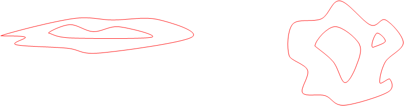
An anomaly at surface can be the surface expression of ore. It could be geophysical, geochemical or an outcrop. A linear anomaly probably represents a steep-dipping tabular body – an equidimentional anomaly probably represents an equidimentional source, although there are other possibilities.
A linear anomaly (i.e. one that is at least 3X as long as it is wide) has a fair chance of being caused by the intersection with the surface of a tabular bedrock source which has at least a moderate to steep dip. Think of a fault fill or a mineralised horizon within a stratified sequence. An irregular-shaped anomaly with roughly ovoid shape could represent a bedrock body with the same shape (irregular and equidimentional). Disseminated mineralisation in intrusive porphyry perhaps? Or it may be the expression of a tabular body with zero or very low dip (manto, palaeoplacer?).
To test the linear anomaly you need to step of to one side and drill an angle hole that will pass directly beneath the centre of the anomaly (or, if a geochemical anomaly, the part with the best assays numbers). You may not know the dip of the causative body: in which case you will have to plan on two holes collared on opposite sides of the anomaly and targeted to cross directly below the surface expression.

Cross sections showing first drill holes to test a linear anomaly. If the dip of the body is unknown, two holes may be needed.
The initial holes will need to intersect the hoped-for ore body at a depth sufficient to avoid any transported surface deposits and (generally) below the level of surface oxidation and weathering. However, the planned intersection should not be so deep that it runs the risk of passing completely below any bedrock source, or hitting the source at such a depth that it cannot be reliably projected back to surface. As a rule of thumb the depth of an anomalous body can be expected to be at least half as deep as its surface expression/outcrop is long. This thinking did not work for Broken Hill, but all rules of thumb have their exceptions, and in the absence of additional knowledge, the exploration geologist can only play the odds. Thus the first hole to test a 100m long surface linear anomaly should not aim for an intersection at much more than 50m depth. With all these considerations, the first hole into any linear anomaly will normally aim for an intersection at 50-100m vertical depth.
For the surface anomaly with the ovoid, equidimentional shape, the targeting strategy is much simpler. Set the rig up in the centre of the anomaly (or on the best assay numbers) and drill a vertical hole. If you reach 100m metres and still have not explained the anomaly, you should probably move on to your next best anomaly. Certainly, some new thinking is called for.
Now back to our first example – the linear anomaly. There are two possibilities: either our first 1-2 holes have intersected ore or potential ore, or they have not. We will call the first possibility Scenario A and the second Scenario B.
With Scenario A: where do we drill the next few holes? This is a dangerous time. Managers get excited, champagne is bought, phrases such as “foot in ore” are used and a statement made to the Stock Exchange. There is a temptation to place the next drill hole a long distance along strike or to a great depth in order to rapidly establish the size of the thing that you have found. But be patient. Ore bodies – even big ones – can be remarkably easy to miss as the Broken Hill example illustrates. Before going for the holes that will prove up the large tonnage that you want, you need to gain geological knowledge, and that can only come from the synergy that drilling a number of close-spaced holes on adjacent sections can provide. The information from 2-4 holes, intersecting the target at depths 50-150m, on each of 2-3 sections spaced no more than 40-50m apart along strike, can give this knowledge by being combined to build up a 3-D picture of the potential ore body and its host environment. Okay, the numbers I quote are perhaps unduly prescriptive, but you get the idea. These are the critical holes and the project geologist has to work very hard, collecting geological information from holes, plotting that information by hand on section as the holes are drilled, making sectional interpretations and combining them to create a knowledge whose whole is greater than the sum of the individual parts. Computers are very little use to the geologist at this stage (their role comes later) and she has to work long hours and apply maximum effort. Only when the geologist has that knowledge, is it safe to make 100m plus step-outs along strike or to depth.
With Scenario B: where the first holes on section are duds, do we walk away from the anomaly? No, because drilling on one section only tests a 2-D slice through a 3-D body. Further holes should be drilled to test along strike to both sides of the first drilled section. Once again, the step-out should not be too great (40-50m say) and aim for intersection, as before, in the 50-100m depth range. Consider the long section of our anomaly (below) showing a possible configuration of the causative body. The dots represent where the drill holes pierce this section.

A longitudinal section through an anomaly (red line) and a possible bed rock causative body with shallow plunge. Dots are the points of intersection of drill holes with the section.
The first two holes pass below the ore body and miss it. The third hole, on a step-out to the west also misses the ore body because it plunges east at a low angle. The fourth hole finally gets an intersection. Persistence is rewarded. Hole 5 is the next obvious one to drill.
So we return to Broken Hill. With the virtue of hindsight that comes from 130 years of mining and thousands of kilometers of diamond drilling, it is easy to see why the first attempts at drilling in 1908 failed to achieve an intersection at depth. It would be another 10-15 years after the initial diamond drilling before the boomerang-shaped nature of the deposit began to be appreciated.
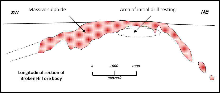
Longitudinal section through the massive lead-zinc sulphide ore body of Broken Hill, NSW. Early drilling beneath the Lode outcrop failed to intersect ore. It would be may decades before the unique coat hanger shape of the deposit was appreciated.